Tensai Manabu-kun Katsushika 2.3.3
Free Version
Publisher Description

Tensai Manabu-kun Katsushika - App displays disaster prevention information for that location by GPS and AR.
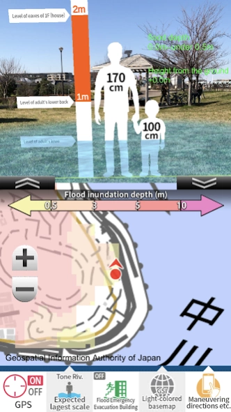
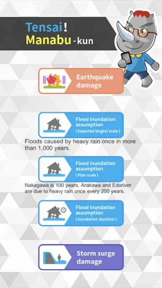
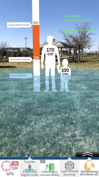
[Tensai! Manabu-kun Katsushika version] is an application that can confirm disaster prevention information such as earthquake disasters and flood disasters in Katsushika-ku, Katsushika-ku, Tokyo and various disaster prevention information such as shelters and flood emergency evacuation buildings on smartphones and tablet terminals. [About the disaster prevention information to be displayed] 1.Flood inundation information This application displays information of the largest scale, the planned scale, and the duration of the flood about the five rivers (Arakawa, Edo, Naka, Ayase, and Tone Rivers). 1) Flood inundation assumption (assumed maximum) The inundation situation when the river was flooded by the flood caused by heavy rain once in 1000 years or more was predicted by simulation. 2) Flood inundation assumption (inundation duration) The inundation duration is displayed based on the provisions of the Flood Control Law, and the inundation situation (time during which the inundation depth of 50cm or more continues when the river is flooded by the flood due to the assumed maximum scale rainfall) was predicted by simulation. 3) Flood inundation assumption (planned scale) The inundation situation was predicted by simulation when the river was flooded by the flood caused by heavy rain once every 200 years (Nakagawa once every 100 years), which is the basis of the flood protection plan. Note: There is no indication of inundation in the ward of the Ayase River. 2.Storm surge inundation information The Tokyo Metropolitan Government has created a map of the expected flooding area for the risk of flooding due to the largest possible storm surge, and displays the expected inundation information and the duration of the flood. 3. Earthquake risk information In this application, among the results of the Tokyo Metropolitan Bureau of Urban Development ,the area risk measurement survey related to the earthquake, displays the fire risk and building collapse risk. 1) Fire risk information In the event of an earthquake, you also need to be alert to fires. Displays the fire risk in five stages. Taking into note the risk of fire based on fire, the rate of fire and usage of electric appliances, etc., as measured by the Tokyo Fire Department, and the risk of spreading fire based on the structure and spacing of buildings, the spread of fire scaught in the earthquake, We measure the degree of risk of damage in large areas. 2) Building collapse risk information Similarly, it displays the risk of collapse of buildings that need to be alerted in the event of an earthquake. Taking into account the type, structure, building year, and ground characteristics of buildings, we measure the degree of risk of buildings being broken or tilted due to earthquake shaking. 4.Information display of shelters, etc. For earthquake damage, you can display the location information of flood emergency evacuation buildings for shelters, temporary meeting places, evacuation sites, flood sand and storm surge damage. At the same time, the name of the nearest shelter, etc., and the direction and straight estedate from the local point are displayed. [Precautions for use] This app is not intended to be used in the event of a disaster, it is made on the premise that you use it in advance as a preparation for daily disaster prevention. In the event of an actual earthquake or disaster, it may exceed the expectation depending on the scale. Regardless of the area displayed in the app, if there is a risk of fire or collapse due to the damage caused by an earthquake, please act at your own risk. [About supervision] Supervised by Professor Takaaki Kato, Institute of Industrial Science, The University of Tokyo "Tensai! Katsushika edition inquiries Katsushika City Crisis-Management Division 052000@city.katsushika.lg.jp [What is AR hazard scope?] For inquiries about AR hazard scope, please click here. Cad Center Co., Ltd. https://www.cadcenter.co.jp/products/archives/7
About Tensai Manabu-kun Katsushika
Tensai Manabu-kun Katsushika is a free app for Android published in the Food & Drink list of apps, part of Home & Hobby.
The company that develops Tensai Manabu-kun Katsushika is CAD CENTER CORPORATION. The latest version released by its developer is 2.3.3.
To install Tensai Manabu-kun Katsushika on your Android device, just click the green Continue To App button above to start the installation process. The app is listed on our website since 2023-10-18 and was downloaded 8 times. We have already checked if the download link is safe, however for your own protection we recommend that you scan the downloaded app with your antivirus. Your antivirus may detect the Tensai Manabu-kun Katsushika as malware as malware if the download link to jp.co.cadcenter.ARHazardScopeKS is broken.
How to install Tensai Manabu-kun Katsushika on your Android device:
- Click on the Continue To App button on our website. This will redirect you to Google Play.
- Once the Tensai Manabu-kun Katsushika is shown in the Google Play listing of your Android device, you can start its download and installation. Tap on the Install button located below the search bar and to the right of the app icon.
- A pop-up window with the permissions required by Tensai Manabu-kun Katsushika will be shown. Click on Accept to continue the process.
- Tensai Manabu-kun Katsushika will be downloaded onto your device, displaying a progress. Once the download completes, the installation will start and you'll get a notification after the installation is finished.
